
The 1964 guide to the ski roads of the South Island.
WE HAVE TO DRIVE TO THE SNOWLINE HERE, UNLIKE IN OTHER PARTS OF THE WORLD, AND THE ROAD UP TO ANY NEW ZEALAND SKI FIELD IS AN IMPORTANT PART OF ITS FOUNDING STORY.
Early paths carved by bulldozers, winches and good keen humans opened up accessibility for snow-lovers to explore slopes they had only dreamed of before. Today, the ski field road is part of the journey: checking the snow report for the chain call (“chains on 4WDs” = “powder day!”), moving your passengers to the back for more traction, unwinding as the road unwinds with you on the way down after a long day of missions. Many of these access roads are unsealed. A few are downright gnarly. Most have epic views. Annabel Wilson and Laura Williamson review a few of their favourites.
Safety note: We’ve commented on the “terror factor” of each road, because that is definitely a thing. But we would like to point out that all of these roads are exponentially safer than New Zealand’s highways of doom, and over the years, Laura’s 1999 Toyota Starlet made it to the top of every one of them, except Mount Olympus. That road is not Starlet compatible.
CORONET PEAK
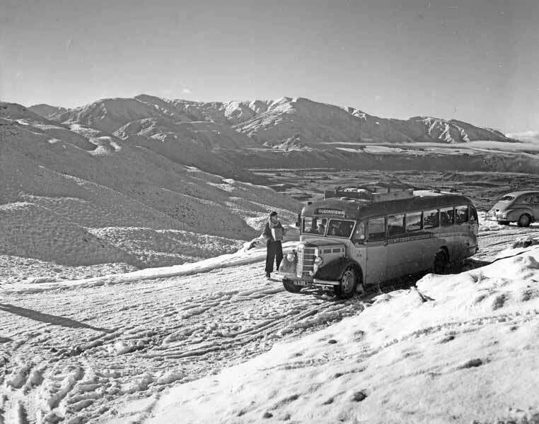
The OG ski field road. In July 1947, Henry ‘Harry’ Wigley installed a rope tow designed by his mate Bill Hamilton (inventor of the Hamilton jet) to give skiers the chance to do laps above Skipper’s turn-off at Coronet Peak station. My dad (who was eight years old when Coronet Peak opened commercially) was among the post-war boom of skiers who caught the bus from Queenstown to the hut and tow. He remembered the road was quite treacherous in those pre-climate change days, when snow fell down to low levels all winter.
“We always chose the 8 o’clock bus because it was driven by a fellow called Snowy Hansen. He had white hair and was of Swedish extraction. Snowy, along with a huge labrador, would take hopeful skiers up the mountain.” Dad liked to sit down at the back of the bus with its lovely smell of hot pies; Snowy transported the pies for the canteen, as well as his passengers and one happy dog. “His old Labrador dog was kept warm — it actually lay on top of all the pies at the back of the bus.” It was cheap too: two shillings and sixpence for bus fare there and back, and three shillings for a day pass.
We need your help
READ MORE
These days, the Coronet Peak road is sealed. Good news, because you need to drive a bit further than where Harry Wigley set up the original rope tow. – AW
Road surface: Sweet, sweet wide sealed road, open year-round.
Views: With the Wakatipu Basin laid out below, the Coronet Peak road has some of Queenstown’s most impressive views.
Terror factor: Minimal.
ŌHAU SNOW FIELDS
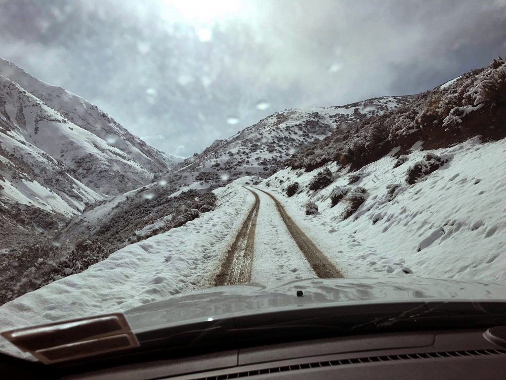
The Ōhau mountain access road is a 9.3-kilometre off-road driving experience deep into the Ōhau Range of the Mackenzie high country. As cited by dangerousroads.org, the road is famously steep and narrow, with an average gradient of 10.1% and an elevation gain of 940 metres. But with drop- offs overlooking the bright blue glacier-fed lake, the drive is also spectacular. Remember that “ōhau” means “windy place” in te reo Māori, so be prepared for all weather. – AW
Road surface: Full metal.
Views: The views up the valley to Aoraki Mount Cook and over Lake Ōhau are stunning, opening out to the whole vista upon arrival at the carpark. Wait ‘til then to get your camera out.
Terror factor: Pretty up there.
MT CHEESEMAN
To drive up to Mt Cheeseman is to wend your way from the karst landscapes of the Castle Hill area, through the beech groves of Craigieburn Forest Park to beyond the snowline, 1540 metres above sea level. Here’s a locals’ secret – Cheeseman is known as a more family-oriented club field than, say, Broken River or Craigieburn. It is therefore THE place to be on a Canterbury powder day. Hop on the Main T-bar and go out wide to enjoy freshies for hours after the powder at the other club fields has been tracked and packed into oblivion. – AW
Views: Beautiful beech to soaring peaks.
Road surface: Gravel, with a few potholes. Suffered a serious wash-out in 2021 which left two slip areas. The clubbies keep it well maintained, though, and they know what they are doing; Mt Cheeseman is the South Island’s oldest field, with more than 90 seasons on the books.
Terror factor: Low-ish, as long as you stick to the 30-kilometre per hour speed limit.

MT HUTT
I worked at Mt Hutt for a number of years, and we rode up every morning in what the staff called “Troopies”, or Troop Carriers. It did feel, some mornings, like going into battle. The trick was to get to work early and snag one of the seats close to the back door. This was both so you could escape quickly if the need arose, and so you could access fresh air, because we were in our twenties and stupid and hungover 80% of the time.
But I miss those days. Wending our way to work on a road that twisted and turned so we saw the mountains, valleys and plains of Canterbury from every angle as we climbed high into the alps was, well, awe-inspiring. Beat the subway any day.
Do stop to read the plaque on ‘Rocky’ the giant boulder on the side of the road, about two thirds of the way up. The 15-tonne boulder, which had crashed into a house in Heathcote during the February 2011 earthquake in Christchurch, is now a moving memorial for the victims of the quake. – LW
Views: Just exceptional. From the top you can see the Pacific Ocean.
Road surface: Variable, but well looked after. Mind the shady bits, they get icy.
Terror factor: It’s an exciting drive, particular through sections like Scott’s Saddle, which is prone to horrifying winds. But take it easy and you’ll be sweet. And the staff are always on hand to help cheerfully with snow chains and advice.
CARDRONA ALPINE RESORT
This is the kindest of the unpaved access roads. It’s not too steep, is well-graded and boasts barriers between you and the longer drop-offs. A pleasure of a drive. – LW
Road surface: Very tidy. A wee bit boggy in spring.
Views: The Cardrona Valley in all her glory.
Terror factor: Low, but beware. The fact the Cardrona road isn’t, as they say, butt- puckering, means the motorists are less cautious. I’ve seen more than a few rental SUVs on their roofs next to the long straight sections, which seem to lull some drivers into briefly mistaking themselves for Hayden Paddon. Slow down please.
MT OLYMPUS SKI CLUB
The road to the Playground of the Gods is not meant to be easy. High above Lake Coleridge in Canterbury’s Ryton Valley, every winter a bunch of hardcore skiers and boarders gather here to invent their own definition of heaven. The road to the Bottom Hut is relatively easy, then it’s all on for 11 kilometres. As a sign on the way up says, “chains and courage are required”. You’ll need a high clearance 4WD ideally. It’s a slow shimmy to the tow shed for the first nutcracker and, warning, if you get stuck or blow a chain, you will stop all the traffic coming up behind you. Avoid this at all costs.
Last year, the Windwhistle Winter Sports Club raced to raise funds to fix the road after the storm that affected several club fields in the Canterbury region. The community pulled together and got the job done, a testament to the can-do attitude of clubbies who love their ski fields, and the roads that get us to them.
Road surface: Shingle.
Views: Rugged backcountry.
Terror factor: Up there.
BROKEN RIVER SKI AREA
Getting to Broken River is all part of the adventure. The six- kilometre, unsealed access road weaves through native forest to the Hanomag Car Park nestled in the Craigieburn Range. From there, the Tyndall Tram can give you a four-minute scenic ride to the ticket office, or if you’re hardcore and it’s a powder day, you can run up the foot track. (PS. Did you know that the Tyndall Tram is New Zealand’s only alpine railway?) – AW
Road surface: Unsealed, chains to be carried.
Views: Deep dark woods, which build your stoke before you emerge above the snowline at the top of the tram or foot track.
Terror factor: Not too bad.
TREBLE CONE
The TC road has been known to put off visitors, some who take one look at the 7.5-kilometre long gravel zig-zag and opt for the free shuttle service instead. It’s a smart move, because then you get to enjoy the sightseeing opportunities on the way up, while your car (especially if it’s a rental or 2WD or you don’t have chains) gets to chill at the bottom.
Cool things to check out during the ascent are all about the ecology (kea, waterfalls, cabbage trees, regenerating beech forest) and the projects that are underway to protect it (predator traps, native seed harvesting and tree replanting). Also, if the wind is right, you might see some people take flight via paraglide from Pub Corner. A treat after a major snowfall is skiing down to the road via the chutes and berms of Hidden Valley.
Road surface: The good folk of TC ensure the road is graded regularly. But when they say Chains To Be Carried they are not kidding. You don’t want to do a 360 or end up in a snowy ditch.
“Little Yellow Digger” type situations are known to unfold on panicky powder days when one car gets stuck, then another 4WD with a winch and a big ego tries to pull them out and gets stuck too. Don’t be that guy! – AW
Views: E P I C.
Terror factor: Fair to middling. Maybe don’t look down when you get to the one-lane-bridge section.
Bonus inquiry: Is Treble Cone the best place on earth for a carpark party? Yes. Loyal snowriders dress up to give every season an epic send-off on Treble Cone Closing Day. Shredding slushy slopes is interspersed with missions to the car for banter and barbecues overlooking one unforgettable view. This year it’s on September 25, 2022. All roads lead to the carpark!