
Auckland may be New Zealand’s biggest smoke, but it’s far from a concrete jungle. It’s a city built on an isthmus surrounded by water and regional parks, and enveloped by ranges of native bush. There’s so much to explore, and luckily for the rest of us, there have been people throughout the history of the city who have thought the same. Auckland has hiking trails snaking all throughout and around it, and the best thing is, they’re all free.

How big is the Auckland region?
The Auckland region is massive, nearly 5,000 square kilometres to be exact, stretching from the Kaipara region in to north to a few miles short of the Waikato river in the south. It reaches out all the way out across the Hauraki Gulf, with Waiheke Island and Great Barrier Island in there, too. For the keen hiker, that’s a lot of space to walk. Whether you want to simply start walking from your front door, or have the time to travel a little further afield, there are options for every kind of trail seeker.

What makes Auckland unique for hikers?
The biggest (and often most surprising) appeal in hiking around Auckland is the diversity of landscapes – the beaches and coastal walks of the North Shore, the deep bush of the Waitakere ranges, and then, of course, there are the islands. The big umbrella of Auckland includes the islands of the Hauraki Gulf, which means hiking in the big smoke covers climbing to the crater of Rangitoto Island, tackling a three day hike on Barrier, or exploring around the Stony Batter Historic Reserve of Waiheke Island. You can catch a ferry to any of the islands from Auckland city, and the view back to the harbour from the deck of the boat is unbeatable.
Another great drawcard about hiking Auckland style is the fact that you can be eating brunch at a suave cafe in the city in the morning, and be deep in the bush by mid afternoon. Many of the regional parks are only half an hour away from downtown Auckland, and the hustle quickly gives way to the sound of native birdsong or lapping waves.
There are also 27 regional parks in the Auckland area; spaces reserved for people to enjoy the birds and the bees and all the other wonderful things New Zealand’s nature has to offer along the way. They’re filled with walking trails, ranging from easy 20 minute loops to hours of track, exploring native bush and gorgeous coastline.
We need your help
READ MORE
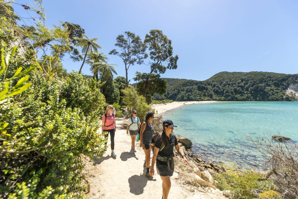
Take the 5.8km Coastal Walk in Long Bay Regional Park, strolling for just over 2 hours along rolling farmland with sea views and endless picnic spots. Or, head further north to the headland of the Shakespear regional park, where a 9.5km easy bay loop track takes hikers past waterfalls, along the beach with views across to Auckland and across open pasture land.
There are countless others, so if you were planning to race through your visit to Auckland, you’d best dust off your hiking boots and slow down a touch. There’s plenty to see here.
How hot does it get in Auckland?
In the summer, from December through to February, the average temperature gets up to 24°C. It’s pretty muggy, though, so it can feel hotter than that.
When is the rainy season?
Being this far from the equator, Auckland, New Zealand has the classic four seasons – summer, winter, autumn and spring. No rainy season. That being said, it does rain a fair bit year round, so pack your wet weather gear, whenever you’re planning on coming.

How do you get around Auckland?
One of the best ways to get around Auckland (if you’re not walking) is to get a rental car, particularly if you want to get to hikes in those hard-to-reach places. Plus, having a car – with extra snacks – to come back to after a long hike is a simple but profound pleasure.
Having said that, there is a Coast to Coast walk that takes hikers from one side of the city to the other, so it is certainly possible to navigate the city by foot.
How is public transport in Auckland?
While there are busses and trains running throughout the city, they’re not really designed for getting to hiking trails, or at least not the out-of-the-way places like the Hunua or Waitakere ranges.
Is Auckland a safe city at night?
Auckland city isn’t especially dangerous, but it’s still not advised to walk alone at night, even if you’ve got your walking pole to swing at potential threats.
What are the best trails in and around Auckland?
The North Shore Coastal Track
This 23km long track is absolutely epic, and follows the bays and beaches of the North Shore. The whole thing takes about six to seven hours, along cliff top walkways, the shoreline and well kept trail sections. The tide may cut walkers off from some beach or beachfront sections, but the trail continues on the road for when this happens. It’s a long day mission, but a popular trail to drop in and do snippets of, like from Long Bay to Torbay, Takapuna to Devonport or Castor Bay to Milford. The views out to the harbour are sensational, and because you can drop in at any point, it’s a great no drive option if you’re based on the North Shore.
If you’re doing the Devonport section, make sure to check out the gun emplacements from the second world war, and take in the 360 degree views of Auckland Harbour, Rangitoto Island and the Hauraki Gulf.
Rangitoto Island
A 25 minute ferry ride from Auckland, Rangitoto Island is a popular day mission – obviously, because it’s a dormant volcano island! It’s an easy walk (two hours return back to the base) to the summit of the volcanic cone, through hardened lava rock formations and the world’s largest pohutukawa forest. Add a fifteen minute side trip to the walk to see the lava caves, just off the Summit Track. It’s worth the detour – how often do you have the chance to crawl through a lava tunnel?
For those who aren’t satisfied with the adventure factor of a hike to the top of a volcano, there’s an alternative travel option: kayak from Devonport, a two hour one way paddle across the harbour. Helluva trip.
Hunua Ranges
The beautiful Hunua Ranges regional park is the largest area of native forest in Auckland, and less than an hour’s drive from the city centre. It’s chocca with waterfalls, hiking trails, iconic New Zealand rainforest and native wildlife. A favourite is the 8km Cosseys Gorge and Masseys Road Loop Track, which, while moderately easy, has plenty of stairs and takes about three hours. It’s a great way to train for steeper walks, and the trail takes hikers past Cosseys Reservoir.
Prefer to explore on two wheels than to walk? Take the easy loop bike track.
Waitakere Ranges
The popular Waitakere Ranges Regional Park is one of the best and most beautiful places Auckland has to offer, and easily competes with some of the other famous hiking spots in New Zealand.
The Upper Huia Reservoir Track is a fantastic hike. It’s a medium difficulty 17km track, and offers about four hours of hiking, past two dams and an old mine, and through native trees and Nikau palms, the only endemic palm species to New Zealand.
If you’re shorter on time, the Coman’s track is an easy one hour (one way) trail, clambering through native bush with views down to the beach.
Coast to Coast
Hike across Auckland, from one coast to the other, through areas of cultural and historic significance. The hike takes about five hours, as you watch the city unfold before you and cross volcanoes, parks, neighborhoods and shorelines. The best thing? The sand changes from black to white (or the other way around).