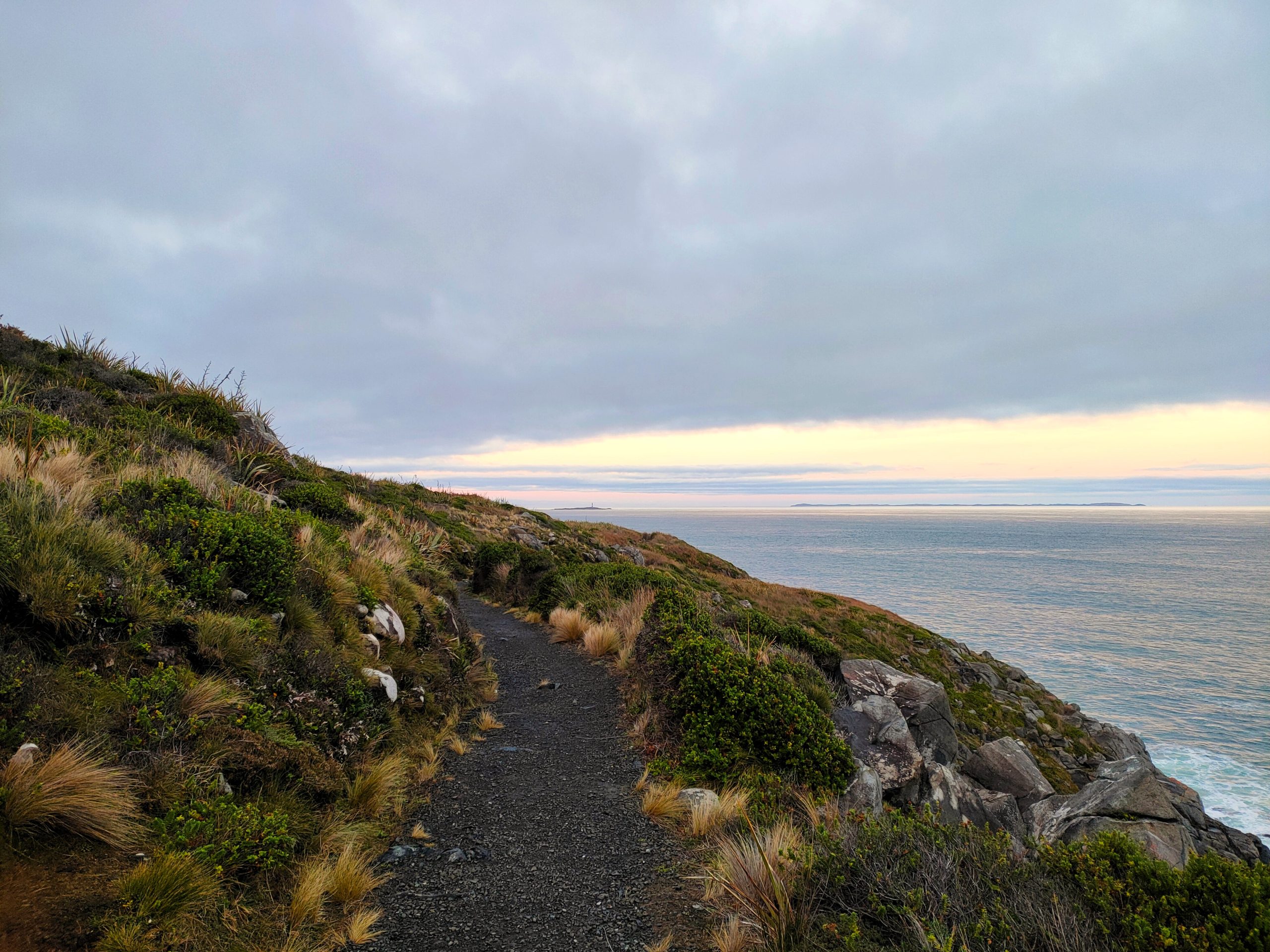
Between Bluff and the Foveaux Strait, a ramble along the Foveaux Walkway feels like skirting the edge of the earth.
We’re just pimples on a gnat’s back. It’s a colourful metaphor. But strolling along the Foveaux Walkway, I realise it’s true almost as soon as the wizard says it.
My companion on this day is Noel Peterson. Also known locally as the Green Wizard, he is a well-bearded Bluff local passionate about the environment and community wellbeing. The weather is as indecisive as a cat presented with the options of jumping on a bed or crawling under it. One moment, it’s bright and sunny, not a cloud. Another, salt-scented fog rolls in, and it’s as misty as the moors. I could ask Noel to cast a spell for fair weather. But doing so might rob our little adventure of its hero’s journey feel.
Either way, it’s sunny as we start our trek along the roughly 7.6-kilometre path. The walkway follows along the western, southern and eastern shoreline of the Bluff Peninsula, between the slopes of 265-metre-high Motupōhue / Bluff Hill and the dark blue, oft-moody Foveaux Strait. It can take about 2.5 hours to complete from end-to-end if going at a casual pace—that is, if one doesn’t stop to admire the scenery or have a snack. People of all ages and fitness levels can do it, though, as we discover, the path isn’t always smooth.
Further to the wizard’s comment on gnats and skin conditions, there is indeed a sense of our smallness as we descend wrinkly hills, which from a distance look like pieces of clay through which huge fingers have scraped. We could be in a giant’s garden. The sinewy, golden grass is head-height in spots, though the well-trodden walkway is easy to follow from where we begin near the Bluff town sign, which sits off State Highway 1 next to an aluminium-sided warehouse. There’s a staircase outside seemingly leading to nowhere.
We need your help
READ MORE
Everything else is big, too. The rocks, many covered in moss and lichens, are as large as houses. Some are even bigger. Only a retreating glacier or indeed a giant could have deposited them here. Even many of the sprawling hebe bushes—this variety sporting burnt-orange flowers—are tree-sized.
Walking this track feels like tiptoeing along the edge of the known world, like something incomprehensibly vast lies beyond. And something does.
About 30 kilometres across the Te Ara-a-Kiwa / Foveaux Strait is wild, marsh-filled Rakiura Stewart Island. Then, after thousands of kilometres of open, blue ocean and mountain-high waves, is the colossal whiteness of Antarctica. There’s a sense of possibility here, that anything could be around the next bend.
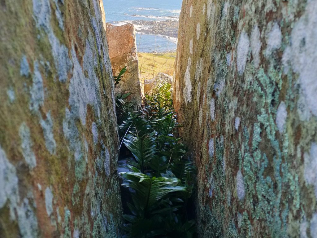
Not long after beginning, we come upon a pair of jagged rocks, sticking out of the ground like huge spikes or broken, petrified pieces of wood. Noel goes closer to check them out. The wizard calls me over. Between the granite slabs is an entire world: a green, prehistoric jungle, visible only up close. Dense patches of broad-leafed ferns compete with twisting vines for space. There’s so much foliage, it’s impossible to see through it all. There’s a faint, sweet scent vaguely reminiscent of citrus. It’s the kind of magical, hidden place elves might live in undiscovered.
Nearly invisible against the deep green of the ferns is a spider the same colour. The tiny arachnid sits on a piece of web stretching between the rocks, as if balancing on a tightrope. Noel takes a picture. He says he’s never seen a spider like this one.
(We go over the photo again a few months later, and Noel thinks it’s a Green Orbweb Spider. Although found throughout Aotearoa and not listed as threatened, they can be difficult to spot because of their camouflage. As evidence: when we look away for only a moment, it takes a couple of seconds to find the spider again, even though it hasn’t moved.)
On this part of the walkway, the hills slope down towards the sea. The Foveaux Strait licks greedily at the rocky cliffs where the hills end. Dozens of ships have wrecked in the strait’s rough waters. But the strait is also a food source. As a large sign informed us at the start of our walk, it has been providing meals and protection since people arrived at least 700 years ago. Bluff’s now-famous oysters also come from its waters.
Because of the waves, there’s a constant soundtrack of pounding surf. But that’s just the percussion section. Wind rustles the tussock-y grass and whistles between the rocks, forming another part of this natural orchestra. The calling birds make up another. Dozens of red- and black-billed seagulls soar and dive—their cackling is the loudest. It often comes as they waddle along the ground, yellow eyes darting around as if they’re in the middle of committing a robbery and don’t want to be caught. Other birds have a more silvery timbre, like an assortment of jovial flutes or horns. Black and white shags aren’t as common as the seagulls, but their occasional calls almost echo as they’re carried on the fresh breeze. Little brown birds fly above the others. I can’t tell if they’re sooty shearwaters or skua, the great wanderers sometimes seen hundreds of kilometres inland in Antarctica.
Part of the Foveaux Walkway—namely, the more open areas around its western end—goes through private farmland. Fluffy white sheep munch on grass behind fences on either side of the path, seemingly oblivious to our presence. Every now and again a little brown rabbit scurries past.
We don’t, however, encounter any penguins and seals. They are sometimes seen along the walkway, I’m told. Penguins and seals also mean animals that eat them—including Great White Sharks. A Bluff outfit even offers—controversially because of the alleged impact on oyster farming and the risk of sharks becoming habituated to people—shark cage diving experiences in the Foveaux Strait. But we don’t see any telltale fins.
The dips and rises in the path are almost reminiscent of the hill country of the Scottish Highlands. The mood is cheery as we walk and talk.
Every now and again we meet fellow walkers. We chat with a young Bluff couple out for a stroll, and more than a few people jogging or walking with their dogs. Everyone is friendly and not a single dog barks at us. There is also a noticeable lack of rubbish on or beside the path.
What we do run into, however, is a bog. The slurping, sucking mud pulls us down and shoes are soon swallowed by the muck. We try to walk through patches that look drier, but it’s a losing battle. The mud comes up past my ankles and it’s a struggle to pull my feet out. The swampy mire stretches on for a considerable distance, too—at least until it looks like the walkway turns to the left, around Bluff Hill. It’s clear we’re not going to be able to cross the swamp here.
We attempt to make our way to higher ground, where it might be drier. Instead, we find ourselves at a small dam or reservoir, flowing from which is a little stream. Perhaps this is the source of the bog.
Noel is undeterred. He proposes another idea: we turn around, then walk in from the other direction.
It’s a short drive in his two-seater, 2014 Smart Fortwo electric vehicle to Stirling Point, the other end of the Foveaux Walkway. This is the most popular direction from which to walk the track because of the ample parking and public toilets. This is also the end (or the start, depending on which direction you choose), of New Zealand’s 3000-kilometre Te Araroa trail. Stirling’s signpost, which marks the distances to locations like London (18, 958 kms), Sydney (2000 kms) and Dog Island (6 kms) is a selfie-must for all TA walkers.
Past the famed sign, which many people (falsely) think marks the southernmost point of the South Island—about half of the Foveaux Walkway is further south, and Slope Point to the east is the actual southernmost point—is a bit of gravel leading into what looks like a dark forest. Unlike at the other trailhead, there’s an extreme sense of closeness here, of being shielded from the wrath of the elements and storms that come up from Antarctica and the Southern Ocean.
The gravel trail hugs the steep cliffs carpeted in green ferns and trees. Some of the twisting tree boughs stretch out and cover the sky above the trail, creating green, living tunnels to walk through. The surf’s also much louder here. It roars so thunderously we can barely hear the gravel crunch beneath our feet.
Then there’s the mist. It’s ever-present, perhaps influenced by the constant jets of spray shooting up from the pounding waves to our left. There’s so much of it, and the damp is so strong, I remove my glasses so I can wipe them down to dry them. Several times.
Again, there’s the sense we’re just small witnesses to nature’s daily routine. The waves would still slam into the rocks without us. The mist would still swirl among the trees.
Many trails also fork off from the walkway. There’s a steep section up to the top of Bluff Hill with views across the strait and north to Invercargill, and the Takitimu Mountains beyond. Another goes to a historic gun battery, installed in case of Japanese invasion during the Second World War.
We continue on the main path. Eventually, the murky jungle gives way to high flax, and the landscape again opens. We’re back to the wide-open areas of rocks we saw when we were walking in the other direction. The exposure means we’re buffeted by a constant, strong breeze as the sun begins going down, bathing everything in a golden sheen.
At the southern end of the Foveaux Walkway is the aptly-named Lookout Point. During the nineteenth century, atop a rocky outcropping known as matai in te reo Māori, men would watch for whales, while a boat waited below to react if they saw anything. With an outlook across the Foveaux Strait to Stewart Island, Lookout Point is still ideal for spotting tohorā / Southern right whales, who swim there regularly. Scanning the darkening water, I think I see a large shape surface before sinking back beneath the waves, but it’s difficult to be certain what it is.
On clear nights when conditions are right, this is also a good spot from which to see the Aurora Australis, the Southern Lights. More regularly, it offers a vantage point to take in sunsets for which “mythic” is a fair description. As we watch the swirling gold, orange, red and pink hues, the word does not seem an exaggeration.
We sit on the rocks for some time. The journey hasn’t been quite what I expected. But every moment has been beautiful. As the lavender sky becomes a deep purple, then indigo, I am not worried about making our way in the dark back to the lights of Stirling Point and Bluff.
We can be pimples on a gnat’s back.
Words and photos: BEN MACK